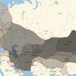
This map is a spectacular example of how data reshape public perception and knowledge. Very simple in nature it nevertheless shocks an average citizen by giving clarity to the data usually buried in obscure tables. East versus west, federal versus private, – the contrast is sharp and reverberates in the minds entangled with American history. […]


 – The Public Domain Review")
 – The Public Domain Review")


 – The Public Domain Review")


